Today is the day I attempt to climb onto the Roof of Japan via the Norikura Skyline Road. This road only recently reopened in May and it is usually closed for more than half the year due to extremely heavy snowfall in the higher parts of the mountains.
Leaving my stuff at Hirayu Prince Hotel where I would be staying later in the night, I set off for the start of the Norikura Skyline Road. To get there from the onsen village of Hirayu, first I needed to climb 5km! It was a hard climb and I`m glad I did not attempt the Skyline Road with all my luggage... I would never have made it to the top!
The Norikura Skyline Road is apparently the highest public road in the whole of Japan and it is closed to personal vehicles. The only way to get to the end of the road, is to either take a taxi or a bus to Norikura Tatami-daira. From Norikura Tatami-daira, hikers then start off on their treks to the nearby mountain peaks.
The winding uphill road to the start of the Norikura Skyline

Finally reaching the beginning of the Norikura Skyline Road after 1 hour of climbing from Hirayu Onsen, I meet a group of cyclists who were also going to the end of the skyline to Norikura Tatami-daira Bus Terminal.
Speaking to Taicho, an IT engineer, he told me that the annual Norikura Skyline Hill Climb would be held the next day, so they were there one day early to practise the route. Setting off together, we did a relaxed pace of around 5km/h. The average gradient of the road was around 15% so we took our time to climb.
Start of the Norikura Skyline Road
Taicho and his girlfriend (who also road a roadbike) coming round a corner
Taking a break to take some photos
As we climbed higher and higher, the air started to grow thinner and it also became significantly colder. When I left Hirayu Onsen village, the temperature was around 15 degrees Celsius. By the time I was halfway up to Norikura Tatami-daira, the temperature had already dropped to around 8 degrees Celsius. Luckily, we were constantly pedalling so this kept us relatively warm still. Most of the cyclists were also just wearing their cycling tights and jerseys.
If you look at the picture below, you`ll see that the road is slanted upwards to the right. This isn`t cause the photographer tilted the camera... Its cause of the gradient of the road!
About half way up to the top
Almost there - 1/3 more to go!
With about another 5km to go to the end of the road, we began to pass by snow-covered slopes! This was my first time touching snow in more than 10 years! According to Taicho, this area is almost always covered with snow throughout the year. In the winter, the snow piles up more than 7m high so they have no choice but to close the roads.
Crossing into the snow-covered region
Cycling in valleys of snow and ice
About 1km from the top, it started to become very foggy
As we approached Norikura Tatami-daira, we saw that there were people skiing! This area is the only place where you can still ski in the summer. Unfortunately, in the winter the snow is too thick to build a ski resort here, so there aren`t any chairlifts.
Skiiers take the bus up to Norikura Tatami-daira with all their ski equipment then they walk to the top of the slopes to ski down. Then when they reach the bottom, they repeat the whole process again! Tiring huh... but no choice if you want to ski in the summer! hahaha...
Can you see the skiiers on the slope?
Walking up and skiing down
3 hours after we had left the start of the Norikura Skyline Road, we finally reach the end at Norikura Tatami-daira. Suddenly, Taicho removed a huge pot from his backpack and opened it to reveal the `oden` that was inside! haha... he had carried the entire team`s lunch on his back throughout the climb as training!
Someone else produced a gas stove then we had steaming hot `oden` at 2,800m above sea level. The hot food and soup was really a welcome treat in the sub-zero temperatures!
The Team - Sakamichi Jitensha Tsukintai (Roughly translated as the Uphill Chiongsters)
A bag of coconut cookies I got as a gift from one of the cyclists
 Me, Taicho-san and our bikes
After lunch, the team went back down to the beginning of the road to settle their registration and administration for the race the next day. As for myself, I initially wanted to take the 3hr round trip hike to the peak of Mt. Norikuradake. Unfortunately, according to the tourist office, the path to the peak was still covered in deep snow, so it would be difficult to go without proper mountaineering gear. So, I had to make do with climbing the nearby Mt. Fujimi.
The climb up to the top of Mt. Fujimi
Reaching the peak of Mt. Fujimi (2,842m above sea level), the view was spectacular! Although it was not as high as Mt. Norikuradake, from Mt. Fujimi I could see almost all the peaks of the Japan Alps. Standing here, I realise why the Japan Alps region is called the `Roof of Japan`!
Mt. Fujimi - 2,842m above sea level
Eating my bento from Eitaro Ryokan at the top of the mountain
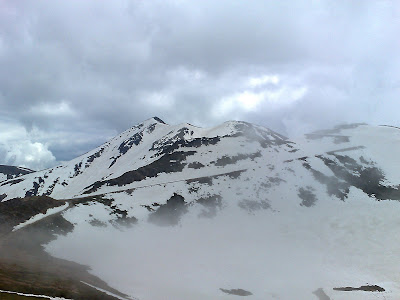
A great view of the surrounding peaks
The path to the top of Mount Norikuradake
Norikura Tatami-daira Bus Terminal
After my second lunch of onigiri and eggs, the fog started to clear so I made my way down from Mt. Fujimi back to Norikura Tatami-daira. Along the way, took some really nice shots now that the sky was much clearer.
Entrance of the path to the top of Mt. Fujimi
Mount Fujimi
My first time walking in snow since 1995
The beautiful mountains that surround Norikura Tatami-daira
After almost 2 hours at Norikura Tatami-daira, I decide to head back down to Hirayu Onsen. The downhill was ride was great! Even pressing both my brakes, I was still going at around 25km/h. Its a good thing cars weren`t allowed on that road! hahaha...
It took me a whole 4 hours to get from Hirayu Onsen to Norikura Tatami-daira, but the trip back down took a mere 30mins! The climb up was really tough, but the view was definitely worth every drop of sweat!
Next stop - Kamikochi, heart of the Japan Alps National Park.


 Inside the main hall of the temple, there were scores of visitors. Some were there just for the sightseeing but many others were there to pray. At the entrance of the temple, there was a wooden statue of a famous Buddhist disciple (not sure whats the name). Apparently, if you had an ailment in any part of your body, you could have it healed just by touching the corresponding part on the statue! Most parts of the statue had been worn smooth by the hands of countless visitors and according to the guide, the face of the statue had been recently replaced because all the features had been worn off by the touching!


 View of Matsumoto City from the top floor of the main tower in Matsumoto Castle